Lacak Lokasi Cuma Pakai Nomor HP?
Ini Realita vs Ekspektasi yang Viral

Spoiler: Ga semudah yang lo pikir. Ini penjelasan LENGKAP dari sisi teknis, hukum, dan realita di Indonesia. Baca sampai habis = ga perlu tanya lagi.

🔍 Pelajari Faktanya
Ilustrasi cyber security neon dengan shield dan padlock menunjukkan konsep keamanan dan privacy dalam tracking lokasi HP

❌ Ekspektasi vs ✅ Realita: Debunking Mitos Viral

Banyak mitos viral di TikTok, Twitter, dan grup WhatsApp tentang tracking lokasi. Mari kita bandingkan ekspektasi yang sering disebarkan vs realita teknisnya.

❌ Lacak lokasi exact cuma pake nomor HP

Kasih nomor aja, langsung ketahuan di mana orangnya, akurat sampai titik koordinat GPS. Banyak jasa online yang janjiin ini.

✅ Butuh akses ke sistem provider BTS

Hanya operator (Telkomsel, XL, Indosat) dan polisi dengan court order yang bisa akses data BTS. Orang biasa: TIDAK BISA. Data ini protected secara legal (UU ITE).

❌ Real-time tracking 24/7 seperti GPS

Bisa pantau pergerakan orang secara live, update tiap detik seperti Google Maps shared location. Katanya bisa tau kemana aja orangnya pergi.

✅ Triangulasi BTS: Akurasi terbatas & tidak real-time

Akurasi 50m-5km tergantung density BTS. Bukan real-time GPS tracking, tapi estimasi dari menara terdekat. Update hanya saat HP handover antar BTS (pindah coverage area).

❌ Jasa online 50rb-500rb bisa lacak siapa aja

Banyak iklan di Tokopedia, Shopee, Facebook, Instagram yang jual jasa 'lacak nomor HP real-time' dengan harga murah. Ada testimoni palsu juga.

✅ 100% SCAM + ILEGAL

Melanggar UU ITE Pasal 31 (pidana 10 tahun) dan UU PDP Pasal 65 (pidana 6 tahun). Data BTS tidak bisa dibeli atau dijual. Scammer cuma ambil uang lo, data ga akan dikasih apapun.

❌ Bisa lacak meski HP target mati/offline

Katanya ada teknologi canggih yang bisa lacak HP bahkan dalam keadaan mati atau airplane mode. Ada yang bilang pakai 'battery signature'.

✅ HP HARUS nyala dan connect ke jaringan

Tracking butuh HP aktif, SIM card terhubung ke BTS. HP mati = tidak ada sinyal = tidak ada komunikasi dengan BTS = tidak bisa dilacak sama sekali. Battery signature adalah mitos.

❌ Ga perlu akses fisik HP target

Cukup tau nomornya, bisa install spy app dari jarak jauh atau 'hack' sistemnya lewat SS7 vulnerability. Katanya hacker bisa lakuin ini.

✅ Presisi butuh app installed + permission dari user

Tracking presisi (GPS) butuh app installed di HP target + user harus approve permission 'precise location'. Remote install tanpa physical access: TIDAK MUNGKIN (kecuali spyware high-level, butuh exploit mahal).

❌ Semua negara punya sistem tracking otomatis

Kalau darurat tinggal telepon polisi atau emergency hotline, langsung ketahuan lokasi exact seperti di film Hollywood. Semua negara sama.

✅ Indonesia ≠ US (E911)

Sistem 112 Indonesia masih basic Cell ID (akurasi terbatas). US punya E911 dengan mandatory A-GPS sejak 2015 (akurasi <50m). Indonesia belum ada regulasi yang mewajibkan operator kirim GPS coordinates.

💡 INGAT: Kalau ada yang janjiin bisa lacak exact location cuma pake nomor HP, tanpa akses provider atau court order → ITU SCAM. Period. Ga ada cara legal untuk orang biasa akses data ini.

📱 Apa yang REALISTIS Bisa Lo Lakuin (Tanpa Akses Provider)

Oke, sekarang lo udah tau bahwa tracking exact location itu impossible untuk orang biasa. Tapi ada beberapa tools LEGAL yang bisa kasih info LIMITED tentang nomor HP. Ini bukan tracking lokasi real-time, tapi setidaknya bisa kasih context tentang siapa pemilik nomor dan info dasar lainnya.

📞

Truecaller / GetContact: Caller ID & Spam Detection

📚 APA ITU?

Truecaller adalah app yang punya database crowd-sourced dari miliaran nomor telepon. Ketika lo cari nomor, dia kasih info nama pemilik (kalau terdaftar), rating spam, dan lokasi APPROXIMATE (kota/provinsi) berdasarkan area code atau data user yang voluntarily share.

🔬 Technical Detail (klik untuk expand)

Database dibangun dari user Truecaller yang voluntarily share kontak mereka saat install app. Sistem mengagregasi data (nama, area) dan assign ke nomor. Location bukan dari GPS real-time, tapi dari area code (+62-21 = Jakarta) atau self-reported location dari user yang punya nomor itu di contact list mereka.

✅ YANG BISA LO DAPETIN:

  • ✅ Nama pemilik nomor (kalau terdaftar di database mereka)
  • ✅ Rating spam (berapa banyak user report sebagai spam/scam)
  • ✅ Lokasi approximate (Jakarta, Surabaya, dll - level kota/provinsi)
  • ✅ Operator/provider (Telkomsel, XL, Indosat - dari prefix nomor)
  • ✅ Social media links (kalau user connect account mereka)

❌ LIMITASI:

  • ❌ Bukan real-time location (data bisa outdated berbulan-bulan)
  • ❌ Akurasi tergantung database (kalau nomor ga ada di DB, ga muncul info)
  • ❌ Privacy concern (kontak lo di-share ke server mereka)
  • ❌ Cuma level kota/provinsi, BUKAN alamat exact atau koordinat GPS
  • ❌ Berbayar untuk fitur lengkap (free version limited)

🎯 BEST FOR:

Cek nomor tidak dikenal yang nelpon/SMS lo, avoid spam call, identify penipu yang sering pake nomor tertentu, verifikasi nomor bisnis/toko online sebelum transaksi.

Interface Truecaller menampilkan caller ID, nama penelepon, dan spam detection rating
Fitur Truecaller scan and pay menunjukkan berbagai fungsi app untuk identifikasi nomor

Interface Truecaller: Caller ID, spam detection, dan info konteks nomor

📡

HLR Lookup: Cek Status Nomor & Network Info

📚 APA ITU?

HLR (Home Location Register) Lookup adalah service yang cek apakah nomor HP masih aktif, pakai operator apa, dan status roaming. Ini query ke database operator secara legal (via API berbayar), tapi GA KASIH LOKASI SAMA SEKALI. Pure network technical info.

🔬 Technical Detail (klik untuk expand)

HLR adalah database central di setiap operator yang store info subscriber: IMSI (International Mobile Subscriber Identity), MSISDN (nomor HP), operator home network, dan status (active/inactive/ported). HLR Lookup query database ini via SS7 atau Diameter protocol. Response: status + network metadata, BUKAN location coordinates atau personal info.

✅ YANG BISA LO DAPETIN:

  • ✅ Status nomor: Active atau inactive (SIM masih dipake atau udah mati)
  • ✅ Operator/provider: Telkomsel, XL, Indosat, 3, Smartfren, dll
  • ✅ Roaming status: Lagi roaming di luar negeri atau di network home
  • ✅ Number porting history: Nomor udah pindah operator atau belum
  • ✅ Number type: Mobile, landline, VoIP (seperti Skype number), atau toll-free

❌ LIMITASI:

  • ❌ TIDAK bisa lacak lokasi sama sekali (ini common misconception!)
  • ❌ Cuma info network/operator, bukan data personal atau nama pemilik
  • ❌ Status update bisa delay (beberapa jam kalau nomor baru inactive)
  • ❌ Service berbayar (sekitar 0.01-0.05 USD per query, atau subscription)
  • ❌ Rate limiting (ga bisa mass query ribuan nomor sekaligus)

🎯 BEST FOR:

Verifikasi nomor sebelum kirim SMS blast marketing (avoid inactive number dan waste budget), cek fraud/fake number dalam transaksi online, validate database pelanggan untuk CRM system, detect SIM swap fraud.

Dashboard HLR Lookup platform menampilkan analytics dan overview query hasil pengecekan status nomor HP
Tutorial HLR Lookup cara cek apakah nomor telepon masih aktif atau tidak

HLR Lookup dashboard: Cek status nomor dan network info (BUKAN lokasi)

⚡ BOTTOM LINE: Tools ini kasih info CONTEXT (nama, operator, spam rating, status aktif), BUKAN real-time location tracking. Kalau lo butuh tau lokasi exact seseorang → lanjut baca section berikutnya untuk paham teknologi yang beneran bisa (tapi ga bisa lo akses).

🗼 Triangulasi BTS: Teknologi Tracking yang Beneran Dipake Provider & Polisi

Ini dia teknologi yang BENERAN bisa lacak lokasi HP (dengan limitasi besar). Cuma masalahnya: LO GA BISA AKSES INI. Tapi penting buat ngerti cara kerjanya, supaya lo paham kenapa ada mitos-mitos yang beredar dan kenapa jasa 'lacak nomor' itu scam total.

📚 Versi Simpel: Gimana HP Lo Bisa Dilacak

💡 ANALOGI GAMPANG:

Bayangin lo lagi teriak di lapangan yang ada 3 orang berdiri di titik berbeda:


👤 Orang A (BTS 1): 'Suara lo kedengeran KERAS' → Jarak: Dekat (~200m)

👤 Orang B (BTS 2): 'Suara lo kedengeran SEDANG' → Jarak: Menengah (~500m)

👤 Orang C (BTS 3): 'Suara lo kedengeran LEMAH' → Jarak: Jauh (~800m)


Dari 3 info jarak ini, mereka bisa estimasi KIRA-KIRA lo ada di area mana. Ga exact point, tapi ada radius. Makin banyak orang (BTS), makin sempit radiusnya.


Itulah triangulasi BTS. HP lo 'teriak' (broadcast signal) ke menara BTS terdekat, BTS ukur jarak dari kekuatan sinyal + timing, lalu calculate posisi approximate lo. Bukan titik exact, tapi area/zona.

Ilustrasi: Cara Kerja Triangulasi BTS

Diagram triangulasi HP menggunakan Timing Advance dari 3 BTS untuk menentukan lokasi device dengan metode trilateration

Triangulasi menggunakan Timing Advance (TA)

Multiple cell tower coverage overlap menunjukkan area interseksi untuk menentukan posisi HP

Coverage overlap dari multiple BTS

Konsep cell triangulation dengan HP di tengah 3 menara BTS

Concept illustration: 3 BTS triangulation

How cell triangulation estimates device location menunjukkan radius dari 3 BTS yang overlap di tengah

Visualisasi: Overlap radius dari 3 BTS = estimated location area

Technical diagram showing signal strength zones dari BTS dengan visualisasi coverage area dan signal degradation

Signal strength zones: Makin jauh dari BTS, makin lemah sinyal

✅ KEY POINTS:

  • ✅ HP lo selalu connect ke 2-5 BTS terdekat (simultaneously untuk coverage redundancy)
  • ✅ Sistem calculate jarak berdasarkan signal strength (RSSI) + timing (TA/RTT)
  • ✅ Output: Circle/polygon AREA, BUKAN titik exact
  • ✅ Akurasi: Tergantung berapa banyak BTS di area lo (urban vs rural)
  • ✅ Update: Tidak real-time, tapi saat handover (pindah dari 1 BTS ke BTS lain)

🔬 Technical Detail: Parameter & Metode yang Digunakan

Bagian ini lebih teknis. Kalau lo casual reader, boleh skip ke section berikutnya.

📊 PARAMETERS YANG DIUKUR OLEH SISTEM BTS:

1️⃣ Cell ID / Cell Global Identity (CGI)

Identitas unique setiap BTS di dunia. Format: MCC-MNC-LAC-Cell ID

  • MCC (Mobile Country Code): 510 = Indonesia
  • MNC (Mobile Network Code): 10 = Telkomsel, 11 = XL, 01 = Indosat
  • LAC (Location Area Code): Kode area regional
  • Cell ID: ID spesifik menara BTS

Contoh: 510-10-1234-5678 = Indonesia, Telkomsel, LAC 1234, Cell 5678

Fungsi: Kasih tau HP lo connect ke BTS mana. Ini basic info untuk estimasi lokasi kasar (radius coverage BTS itu, bisa 100m sampai 35km tergantung area).

2️⃣ Signal Strength (RSSI - Received Signal Strength Indicator)

Kekuatan sinyal dari BTS ke HP, measured in dBm (decibel-milliwatts).

Range typical:

  • -50 dBm: Very strong (deket banget ke BTS, <100m)
  • -70 dBm: Good signal (200-500m)
  • -90 dBm: Weak signal (1-2km)
  • -110 dBm: Very weak / edge of coverage (3-5km+)

Relationship: Makin lemah sinyal (angka makin negatif), makin jauh jarak dari BTS.

Formula estimasi: Distance ∝ 10^((RSSI_reference - RSSI_measured) / (10 × n))
Dimana n = path loss exponent (2-4, tergantung environment: outdoor=2, indoor=3-4)

Limitasi: Ga presisi karena interference, obstacle, multipath. Margin of error bisa ±200m.

3️⃣ Timing Advance (TA) - Used in 2G/3G

Waktu yang dibutuhin sinyal dari BTS ke HP, measured in microseconds atau bit periods.

Cara kerja: BTS kirim signal ke HP, HP respond. BTS ukur round-trip time, lalu adjust timing agar semua HP yang connect ke BTS itu synchronized (avoid collision).

Formula: Distance ≈ (TA × 550 meters)

  • TA = 0: HP sangat dekat BTS (<550m)
  • TA = 1: 550m - 1.1km
  • TA = 63 (max in GSM): ~35km

Presisi: Lumayan akurat di rural (few obstacles), tapi error di urban karena signal reflection dari gedung (multipath interference).

4️⃣ Round Trip Time (RTT) - Used in 4G/5G

Evolution dari TA. Total waktu signal pergi-pulang BTS ↔ HP, measured lebih akurat dengan nanosecond precision.

Cara kerja: BTS kirim reference signal, HP respond, BTS calculate exact timing.

Formula: Distance = (RTT × speed of light) / 2
Speed of light ≈ 300,000 km/s = 300 m/microsecond

Akurasi: ±50-100 meter (ideal condition, line-of-sight)

Advantage dibanding TA:

  • Lebih presisi (LTE/5G = better timing resolution)
  • Less affected by multipath (advanced signal processing)
  • Combine with other parameters (AoA, RSSI) untuk presisi lebih tinggi
5️⃣ Angle of Arrival (AoA) - Advanced Method

Sudut datangnya sinyal dari HP ke BTS antenna. Butuh BTS dengan multi-antenna array (MIMO - Multiple Input Multiple Output).

Cara kerja: BTS punya 3+ antenna yang measure phase difference dari signal yang datang. Dari phase difference, calculate angle/direction HP relatif ke BTS.

Combined method: Distance (dari RTT) + Angle (dari AoA) = More precise location
Contoh: 'HP ada 500m dari BTS-A, direction 45° northeast' → pinpoint lebih akurat

Technology: Mostly 4G Advanced & 5G dengan beamforming capability

Akurasi: Combined dengan RTT bisa achieve 10-50m accuracy (best case, dense urban)

📐 METODE TRILATERATION (Bukan Triangulation, Technically):

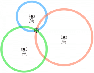
STEP 1: Ukur jarak HP ke minimum 3 BTS

Contoh data:

  • BTS-A (Jakarta Selatan): 500m ± 100m margin of error
  • BTS-B (Jakarta Selatan): 700m ± 100m
  • BTS-C (Jakarta Pusat): 900m ± 150m

STEP 2: Gambar circle radius dari setiap BTS

  • Circle A: Center di koordinat BTS-A, radius 500m
  • Circle B: Center di koordinat BTS-B, radius 700m
  • Circle C: Center di koordinat BTS-C, radius 900m

STEP 3: Cari overlap area (intersection)

Idealnya: 3 circle bertemu di 1 titik → exact location

Realita: 3 circle overlap jadi AREA (bukan titik) karena:

  • Margin of error dari measurement
  • Multipath interference (signal bouncing)
  • Timing inaccuracy
  • Environmental factors

STEP 4: Calculate confidence level

Output: 'HP berada di area ini dengan 80% confidence, radius ±200m'

Confidence level tergantung:

  • Number of BTS (makin banyak = makin confident)
  • Signal quality (strong signal = more accurate)
  • BTS geometry (BTS tersebar merata = better vs. semua BTS di 1 direction = worse)

🚫 Access Control: Kenapa Lo Ga Bisa Akses Sistem Ini

Data triangulasi BTS adalah data RESTRICTED dan PROTECTED oleh hukum. Hanya pihak tertentu dengan legal authority yang bisa akses.

OPERATOR / PROVIDER

  • Telkomsel, XL Axiata, Indosat Ooredoo, 3 (Tri), Smartfren
  • Punya BTS infrastructure & akses real-time data
  • Database: Cell ID, TA/RTT, RSSI, subscriber info, location history
  • Purpose: Network optimization, maintenance, legal compliance
  • Access level: FULL (semua data technical & location)

LAW ENFORCEMENT (Dengan Court Order)

  • Polisi (Polri, Polda, Polres)
  • Intelijen (BIN - Badan Intelijen Negara, Bais TNI)
  • Kejaksaan, KPK (untuk kasus korupsi)
  • Komisi Pemberantasan Terorisme

SYARAT MUTLAK:

  • Harus ada Penetapan / Surat Perintah Pengadilan
  • Untuk investigasi kriminal (pidana berat, terorisme, korupsi)
  • Tidak bisa arbitrary / sembarangan
  • Process: Request ke operator → operator verify court order → kasih data

EMERGENCY SERVICES (112)

  • Operator 112 (emergency call center Indonesia)
  • Basarnas (SAR - Search and Rescue)
  • Rumah sakit emergency response

Trigger: Otomatis saat lo nelpon 112, sistem kirim basic location (Cell ID)

Akurasi: Tergantung area (50m-5km), tidak presisi seperti GPS

Purpose: Untuk emergency response, bukan tracking biasa

YANG TIDAK BISA AKSES (ILEGAL)

  • ❌ Orang biasa / individu (termasuk lo)
  • ❌ Private investigator / detektif swasta
  • ❌ 'Jasa lacak nomor' online (100% SCAM)
  • ❌ Company / corporation (kecuali operator sendiri)
  • ❌ Hacker (tanpa legal authority)
  • ❌ Orang tua tracking anak (ga ada legal basis)
  • ❌ Pasangan tracking pasangan (domestic surveillance = ilegal)
🚨

PENTING: Triangulasi BTS adalah tools untuk LAW ENFORCEMENT dengan court order, BUKAN untuk stalking pacar, spy on karyawan, atau tracking anak tanpa consent.


Kalau lo butuh tau lokasi seseorang:

  • 1. ✅ Minta izin (consent) → mereka voluntarily share location via app
  • 2. ✅ Lapor polisi (kalau emergency/kriminal) → mereka yang handle dengan legal process
  • 3. ✅ Accept that you CAN'T track someone without their knowledge legally

There is NO legal way untuk orang biasa akses data BTS. Period.

🏙️🏞️ Realita Akurasi di Indonesia: Jakarta vs Papua

Oke, sekarang lo udah ngerti cara kerja triangulasi. Tapi akurat ga sih di Indonesia? Jawabannya: TERGANTUNG BANGET. Urban (kota besar) vs rural (desa/pedalaman) itu beda DRASTIS. Ini data real BTS density di Indonesia yang bikin perbedaan akurasi sampai 100x lipat.

📊 Density BTS: Kota Besar vs Daerah Terpencil

Density BTS (berapa banyak menara per km²) adalah faktor TERBESAR yang menentukan akurasi triangulasi. Makin padat BTS, makin akurat. Indonesia punya disparitas yang EXTREM antara urban dan rural.

Region (Area) BTS Density (Jarak antar BTS) Coverage Overlap (Berapa BTS simultaneous) Typical Accuracy (Akurasi tracking)
🏙️ Jakarta Pusat 1 BTS per 300-500m Sangat tinggi (5-8 BTS simultaneous) 50-200 meter
🏙️ Surabaya, Bandung 1 BTS per 500m-1km Tinggi (4-6 BTS) 100-300 meter
🏢 Kota Tier 2 (Medan, Semarang, Makassar) 1 BTS per 1-2km Sedang (3-4 BTS) 300-800 meter
🏘️ Kota Kecil / Kabupaten 1 BTS per 2-5km Rendah (2-3 BTS) 1-3 kilometer
🏞️ Desa / Rural Area 1 BTS per 5-20km Sangat rendah (1-2 BTS) 3-10 kilometer
⛰️ Pedalaman (Papua, Kalimantan interior) 1 BTS per 20-50km+ Minimal (often 1 BTS only) 5-50 kilometer (basically useless)

🌍 APA ARTINYA DALAM KEHIDUPAN NYATA:

🏙️
JAKARTA (Urban Dense)

'Lo di Starbucks Grand Indonesia, system bisa detect lo di mall itu (radius ~100m). Polisi bisa tau lo di area Bundaran HI, bahkan bisa estimate lo di gedung mana karena density BTS sangat tinggi (overlap 5-8 menara).'

Real example:

  • Location: Sudirman area
  • BTS detected: 6 simultaneous
  • Accuracy: ±150 meter
  • Confidence: 85%
  • Implication: Bisa tau lo di gedung perkantoran mana (Wisma 46, BCA Tower, dll)
🏢
KOTA TIER 2 (Semi-Urban)

'Lo di Purwokerto atau Pekalongan, system cuma bisa bilang lo di kecamatan mana (radius ~500m-1km). Cukup untuk tau area, tapi ga tau persis di jalan atau gedung mana.'

Real example:

  • Location: Purwokerto Timur
  • BTS detected: 3 simultaneous
  • Accuracy: ±600 meter
  • Confidence: 65%
  • Implication: Tau area (kelurahan), tapi bisa salah jalan
🏞️
DESA (Rural)

'Lo di desa di Sumba atau Flores, system cuma tau lo di kecamatan X (radius 5-10km). Useless untuk tracking presisi. Bisa aja system bilang lo di Desa A, padahal actual lo di Desa B yang 7km jauhnya.'

Real example:

  • Location: Desa di Sumba Barat
  • BTS detected: 1-2 (unstable)
  • Accuracy: ±8 kilometer
  • Confidence: 30%
  • Implication: Basically cuma tau 'ada di wilayah coverage BTS ini', bisa salah desa
⛰️
PEDALAMAN (Remote)

'Lo di pedalaman Papua atau Kalimantan interior, system cuma tau lo di kabupaten (radius 20-50km). Basically cuma tau lo ada di wilayage coverage BTS itu, ga lebih. Untuk tracking individual: COMPLETELY USELESS.'

Real example:

  • Location: Pedalaman Papua Pegunungan
  • BTS detected: 1 (often no signal)
  • Accuracy: ±35 kilometer
  • Confidence: 10-20%
  • Implication: 'HP ini ada di Papua' ← that's it, nothing more specific

🗺️ Peta BTS Density & Coverage di Indonesia

Ini data research actual tentang distribusi BTS di Indonesia. Lihat sendiri perbedaan ekstrem antara Jawa (dense) vs. Papua, Kalimantan, NTT (sparse).

Density distribusi BTS di Indonesia menunjukkan perbedaan ekstrem antara Jawa yang padat vs Papua dan Kalimantan yang sparse berdasarkan research data

Density distribusi BTS di Indonesia (research data)

BTS coverage comparison menunjukkan perbandingan coverage area urban vs rural Indonesia dengan visualisasi geographic disparities

BTS coverage comparison: Urban vs rural Indonesia

Cell tower distribution map Indonesia showing geographical disparities dengan konsentrasi tinggi di Jawa dan rendah di Indonesia Timur

Cell tower distribution map: Geographical disparities

Network coverage analysis across Indonesian regions menampilkan data kuantitatif distribusi BTS per provinsi dan per pulau

Network coverage analysis: Data per region

📌 CARA BACA PETA:

  • Warna gelap/dense/banyak dots: Area dengan BTS banyak (urban) → akurasi tinggi
  • Warna terang/sparse/sedikit dots: Area dengan BTS sedikit (rural) → akurasi rendah
  • Blank/white spots: Ga ada coverage sama sekali (dead zone, no signal)

PATTERN YANG JELAS:

  • ✅ Jawa, Bali, Sumatra bagian Timur: DENSE (1 BTS per <1km)
  • ⚠️ Kalimantan coastal, Sulawesi: SEDANG (1 BTS per 2-5km)
  • ❌ Papua, Maluku, NTT, Kalimantan interior: SPARSE (1 BTS per 10-50km+)

Kesimpulan: Makin padat warna pada peta, makin akurat triangulasi. Makin putih/kosong, makin ga guna buat tracking.

💡

FUN FACT: Jakarta punya ~15,000 BTS di area 664 km² = ~23 BTS per km². Papua punya ~2,000 BTS di area 319,036 km² = ~0.006 BTS per km².


That's 3,800x difference in density!


Makanya akurasi tracking di Jakarta bisa 50 meter, sementara di Papua bisa 50 KILOMETER.

📡 A-GPS: Kapan Tracking Bisa BENAR-BENAR Presisi?

Kalau BTS triangulasi cuma akurat 50m-5km, terus gimana app kayak Google Maps bisa akurat sampai 5-10 meter? Jawabannya: A-GPS (Assisted GPS). Ini teknologi yang BENERAN presisi, TAPI ada syarat ketat yang harus dipenuhi.

📚 A-GPS: GPS + BTS Data = Presisi Tinggi

💡 PENJELASAN SIMPLE:

A-GPS (Assisted GPS) adalah kombinasi dua sistem:


1️⃣ GPS Satellite (dari luar angkasa)
  • • 24-32 satelit GPS yang orbit di 20,000 km altitude
  • • Kirim signal timing yang HP lo tangkap
  • • Calculate position berdasarkan jarak dari 4+ satelit
  • Akurasi: 5-10 meter (outdoor, clear sky)

2️⃣ BTS Assistance Data (dari network operator)
  • • BTS kirim data satelit mana yang visible di lokasi lo
  • • Almanac & ephemeris data (orbit satelit)
  • • Reference time & approximate location
  • Speed up GPS lock dari 5-10 menit jadi 5-10 detik

Kombinasi = FAST + ACCURATE location.

🔬 Technical Detail: Cara Kerja A-GPS

STEP 1: Cold Start (tanpa assistance)

HP cari signal dari 24+ GPS satelit → butuh 5-10 menit untuk 'lock'


STEP 2: Dengan BTS Assistance

  • • HP request assistance data dari BTS via data connection
  • • BTS kasih: Visible satellites list, almanac, ephemeris, reference time
  • • HP langsung tau satelit mana yang harus di-track
  • GPS lock dalam 5-10 detik (100x lebih cepat!)

STEP 3: Position Calculation

  • • HP receive signal dari 4+ GPS satelit
  • • Calculate distance dari timing (speed of light)
  • • Trilateration dari satelit coordinates
  • Output: Latitude, Longitude, Altitude dengan akurasi ±5-10m

STEP 4: Continuous Tracking

  • • Update position tiap 1 detik (real-time)
  • • BTS assist untuk maintain lock
  • • Battery efficient (karena fast lock)

Arsitektur A-GPS System

Diagram A-GPS menunjukkan interaksi antara GPS satelit, mobile device, dan BTS network untuk assisted positioning

A-GPS architecture: GPS satelit + BTS assistance

Struktur Assisted GPS menampilkan flow data antara GPS satellites, network server, dan mobile station

Assisted GPS structure: Data flow diagram

GNSS architecture diagram menunjukkan space segment, control segment, dan user segment dalam sistem GPS

GNSS/GPS architecture: Complete system overview

⚠️ Syarat MUTLAK untuk A-GPS Tracking

Ini yang penting: A-GPS BUKAN bisa diakses sembarangan. Ada syarat ketat yang SEMUA harus terpenuhi. Kalau salah satu ga ada, tracking ga bisa dilakukan.

1️⃣

HP Target Harus Install App yang Minta Location Permission

App harus installed di HP target dan minta 'Precise Location' permission.


Contoh apps:

  • ✅ Google Maps (lo share live location)
  • ✅ WhatsApp (lo share location ke chat)
  • ✅ Find My Device / Find My iPhone (lo setup sendiri)
  • ✅ Family tracking apps (Life360, Zenly) - dengan consent
  • ✅ Uber/Gojek/Grab (lo approve saat pake layanan)

❌ Remote install TANPA physical access: TIDAK MUNGKIN

❌ Orang lain ga bisa install app di HP lo dari jauh

❌ Spyware butuh jailbreak/root + physical access = very difficult

2️⃣

User Harus APPROVE Permission 'Precise Location'

Di Android/iOS, user harus explicitly tap 'Allow' atau 'While Using App' untuk location access.


Permission levels:

  • 'Precise Location': Akurasi 5-10m (A-GPS)
  • 'Approximate Location': Akurasi ~1km (BTS only)
  • 'Deny': App ga bisa akses lokasi sama sekali

❌ App GA BISA akses location tanpa user approve

❌ System prompt permission dialog yang HARUS user tap

❌ Ga ada cara bypass permission tanpa root/jailbreak


Kalau user deny permission → app ga bisa track, period.

3️⃣

GPS di HP Harus Aktif

GPS hardware di HP harus ON. Kalau GPS OFF (airplane mode, battery saver mode), A-GPS ga bisa kerja.


GPS status:

  • ON + High Accuracy mode: A-GPS full precision
  • ⚠️ ON + Battery Saver mode: Reduced accuracy (BTS only)
  • OFF: Tidak ada GPS tracking sama sekali

User control: User bisa matiin GPS kapan aja dari quick settings.

App ga bisa force-enable GPS tanpa user action.

4️⃣

App Harus Running atau Background Access Diizinkan

App harus:

  • • Foreground (actively open) ATAU
  • • Background access diizinkan (Always Allow)

Background restrictions:

  • • Android 10+: Background location butuh 'Allow all the time' permission
  • • iOS: 'Always Allow' permission
  • • User bisa revoke kapan saja

❌ App tertutup total (force stopped) = ga bisa track

❌ Battery optimization kill app = tracking stop

❌ User bisa restrict background access = no tracking

5️⃣

HP Harus Ada Internet & Outdoor (Ideal)

  • Internet: Butuh data untuk BTS assistance & upload location ke server
  • Outdoor: GPS signal lemah indoor, butuh clear sky view

Indoor limitation:

  • 🏢 Mall/gedung: GPS accuracy drop jadi 20-50m (atau ga dapet signal)
  • 🏠 Rumah: Tergantung konstruksi, bisa 10-30m
  • ⛰️ Basement/parking: Sering ga ada GPS signal sama sekali

Kalau GPS ga dapet signal → fallback ke BTS triangulasi (akurasi turun drastis).

🚫

KESIMPULAN:


A-GPS tracking HANYA mungkin kalau:
TARGET VOLUNTARILY install app + approve permission + GPS ON + app running


Ga ada cara untuk track seseorang dengan A-GPS tanpa mereka tau dan setuju.


'Remote tracking' tanpa physical access ke HP target = SCAM atau MITOS.

🚨 Emergency: Perbedaan Sistem 112 (Indonesia) vs 911 (US)

Kalau lo nelpon emergency (112 di Indonesia atau 911 di US), sistem otomatis kirim lokasi lo. Tapi akurasinya BEDA BANGET. Indonesia masih basic (Cell ID), sementara US udah mandatory GPS sejak 2015. Ini kenapa ada gap-nya.

🇮🇩 Sistem 112 Indonesia: Basic Location (Cell ID)

📞 CARA KERJA 112 INDONESIA:


STEP 1: Lo nelpon 112 dari HP lo

Otomatis trigger: Emergency call protocol, prioritas tertinggi di network

STEP 2: Operator menerima panggilan + basic location data

Data yang dikirim otomatis:

  • • Cell ID (BTS mana yang HP lo connect)
  • • Approximate location berdasarkan coverage BTS
  • • Nomor HP lo
  • • Operator/provider (Telkomsel, XL, dll)
STEP 3: Operator tanya detail lokasi verbal

'Bapak/Ibu di mana sekarang?'
'Apa landmark terdekat?'
'Alamat lengkapnya?'

Why: Karena Cell ID ga cukup presisi, butuh konfirmasi verbal

STEP 4: Dispatch emergency services

Ambulans, pemadam, polisi, SAR dikirim ke lokasi based on verbal info + Cell ID

📊 AKURASI SISTEM 112 INDONESIA:


🏙️ Urban (Jakarta, Surabaya):
  • Akurasi: 50-500 meter
  • • Bisa tau area/kelurahan
  • • Butuh konfirmasi verbal untuk exact address
🏞️ Rural (Desa, pedalaman):
  • Akurasi: 1-10 kilometer
  • • Cuma tau kecamatan atau radius BTS
  • • SANGAT bergantung pada verbal description dari caller
❌ LIMITATION:
  • ❌ Ga ada mandatory GPS (operator ga wajib kirim GPS coordinates)
  • ❌ Tergantung density BTS (urban ok, rural buruk)
  • ❌ Kalau caller unconscious atau panik → sulit dapat lokasi exact
  • ❌ Belum ada regulasi yang mewajibkan A-GPS untuk emergency call

💡 CONTOH REAL CASE:

✅ CASE 1: Emergency di Jakarta (Urban)

Situasi: Kecelakaan motor di Jl. Sudirman

112 dapat data: Cell ID → Area Sudirman (radius ~200m)

Operator tanya: 'Di Sudirman sebelah mana?' → Caller jawab 'Dekat Plaza Indonesia'

Ambulans datang: 10-15 menit

Result: SUCCESS (karena area specific + verbal info jelas)

⚠️ CASE 2: Emergency di Papua (Rural)

Situasi: Tersesat di hutan

112 dapat data: Cell ID → Kabupaten X (radius ~30km)

Operator tanya: 'Bapak di desa mana?' → Caller: 'Ga tau, lagi di hutan'

SAR team: Butuh 3-6 jam untuk scan area seluas 30km radius

Result: DELAYED (akurasi buruk, area terlalu luas)

🇺🇸 Sistem E911 US: Mandatory GPS (Presisi Tinggi)

📞 CARA KERJA E911 (ENHANCED 911):


STEP 1: Lo nelpon 911 dari HP lo

Otomatis trigger: E911 protocol (mandatory by FCC regulation)

STEP 2: HP OTOMATIS kirim GPS coordinates + Cell ID

FCC Mandate (sejak 2015):

  • Outdoor: Akurasi minimum 50 meter (within 50m dari actual location)
  • Indoor: Akurasi minimum 50 meter horizontal + Z-axis (floor level)
  • Compliance rate: 80% calls harus meet accuracy standard

Data yang dikirim:

  • ✅ GPS Latitude, Longitude (presisi)
  • ✅ Altitude (floor level untuk indoor)
  • ✅ Cell ID (backup kalau GPS fail)
  • ✅ Confidence level (accuracy estimate)
  • ✅ Nomor HP & carrier
STEP 3: PSAP (Public Safety Answering Point) terima data

Operator langsung lihat:

  • • Map dengan pinpoint exact location
  • • Address reverse geocoding (otomatis convert coordinate ke alamat)
  • • Caller info
STEP 4: Dispatch dengan coordinate exact

Emergency responder dapat GPS coordinate, routing otomatis

Ga perlu tanya 'you're where?' kecuali konfirmasi

Response time lebih cepat (average 7-10 menit di urban)

STEP 5: Text-to-911 (bonus feature)

Kalau caller ga bisa bicara (unconscious, hostage situation):

  • • Bisa kirim SMS ke 911
  • • Location otomatis attached
  • • Operator respond via text

📊 AKURASI SISTEM E911:


Urban & Rural (sama):
  • Outdoor: 5-50 meter (GPS-based)
  • Indoor: 10-100 meter (tergantung building, dengan Z-axis)
  • • Fallback ke Cell ID kalau GPS unavailable
⚖️ MANDATORY COMPLIANCE:

FCC regulation Phase II (2015-sekarang):

  • • 80% calls harus achieve <50m accuracy (outdoor)
  • • 70% calls harus achieve <50m + Z-axis (indoor) by 2025
  • • Carrier yang ga comply = denda besar
  • • All smartphones sold di US harus support E911

⚖️ Indonesia vs US: Kenapa Ada Gap Besar?

Aspek 🇮🇩 Indonesia (112) 🇺🇸 US (E911)
Technology Cell ID (BTS triangulasi) Mandatory A-GPS + Cell ID fallback
Akurasi Outdoor 50m - 10km (tergantung area) 5-50m (mandatory by FCC)
Akurasi Indoor Sama dengan outdoor (ga ada Z-axis) 10-100m + floor level (Z-axis)
Regulasi Ga ada mandate GPS untuk emergency FCC mandate sejak 2015 (Phase II)
Compliance Voluntary (operator bisa kirim GPS tapi ga wajib) Mandatory 80% calls <50m accuracy
Infrastructure Tergantung BTS density (urban ok, rural buruk) GPS-based (urban & rural sama presisi)
Verbal Confirmation SANGAT penting (operator harus tanya lokasi) Optional (GPS coordinates sudah presisi)
Response Time 10-30 menit urban, bisa >1 jam rural 7-15 menit average (GPS routing)
Text Emergency Belum support SMS ke 112 Text-to-911 available di mayoritas area
💡

KEY TAKEAWAY:


INDONESIA (112):

Akurasi tergantung lokasi. Urban = lumayan, rural = buruk.

Selalu kasih verbal description lokasi lo ke operator (jangan expect GPS precision).


US (E911):

GPS presisi mandatory. Operator langsung tau exact location.

Verbal confirmation optional (tapi still helpful).


GAP: Regulasi & budget. Indonesia belum ada mandate untuk GPS emergency.


SARAN: Kalau lo emergency di Indonesia, JANGAN andalkan sistem tau lokasi lo exact. Always siap kasih landmark, alamat, atau coordinate manual (Google Maps pin).

🚨 Jasa 'Lacak Nomor HP' Online: 100% SCAM

Setelah baca semua penjelasan di atas, lo sekarang paham kenapa 'jasa lacak nomor' yang dijual online itu SCAM TOTAL. Mereka janjiin yang IMPOSSIBLE secara teknis dan ILEGAL secara hukum. Ini cara identify scam dan apa resikonya.

🚩 Red Flags: Cara Identify Jasa Scam

Kalau lo liat iklan atau jasa yang janjiin hal-hal ini → 100% SCAM. Ga ada exception.

🚩

Janjiin Lacak Exact Location Cuma Pake Nomor HP

Klaim: 'Cukup kasih nomor HP, kami bisa kasih lokasi real-time dengan akurasi GPS'

Realita: IMPOSSIBLE. Data BTS cuma bisa diakses provider + law enforcement. Orang biasa ga punya akses.

Red flag phrases:

  • ❌ 'Cukup nomor HP saja'
  • ❌ 'Akurasi GPS presisi'
  • ❌ 'Real-time tracking 24/7'
  • ❌ 'Tanpa perlu akses HP target'

Why it's scam: Teknisnya impossible, secara legal impossible.

🚩

Harga Murah (50rb - 500rb)

Klaim: 'Jasa lacak nomor hanya 100rb sekali bayar' atau 'Paket bulanan 200rb'

Realita: Kalau sistemnya beneran bisa akses data BTS provider, harganya GA MUNGKIN semurah itu. Data breach dari provider bernilai MILIARAN (black market price).

Red flag:

  • ❌ Harga terlalu affordable untuk 'illegal service'
  • ❌ Payment via pulsa, e-wallet, crypto (untraceable)
  • ❌ No refund policy

Why it's scam: Kalau beneran bisa, harga black market untuk access BTS data itu ratusan juta to miliaran. 100rb? LOL.

🚩

Testimoni Palsu dengan Screenshot Editan

Klaim: 'Lihat testimoni customer kami, berhasil lacak pacar selingkuh'

Realita: Screenshot fake, foto stock, atau edit Photoshop/Inspect Element.

Red flag:

  • ❌ Screenshot tanpa context (bisa hasil Google Maps screenshot biasa)
  • ❌ 'Customer' ga pernah verifiable (akun palsu, dibeli)
  • ❌ Terlalu banyak 'success story' tanpa bukti real
  • ❌ Ga ada review di platform legitimate (Google, Trustpilot)

How to verify: Reverse image search screenshot mereka → ketauan stock photo.

🚩

Minta Data Sensitif Lo Dulu (KTP, Selfie, dll)

Klaim: 'Untuk verifikasi, kirim KTP dan selfie pegang KTP dulu'

Realita: Mereka collect data lo untuk dijual atau dipake buat fraud lain (loan shark, scam berikutnya).

Red flag:

  • ❌ Minta KTP sebelum service deliver
  • ❌ Alasan verifikasi 'untuk keamanan sistem kami'
  • ❌ Minta transfer dulu sebelum kasih hasil

Risk: Identity theft, data sold to darkweb, dipakai buat pinjol atas nama lo.

🚩

Ga Ada Identitas Jelas (Anonim)

Klaim: 'Kontak via Telegram @anonservice, payment via crypto untuk privacy'

Realita: Anonim karena ILEGAL. Ga ada legal entity, ga bisa dituntut kalau scam.

Red flag:

  • ❌ Cuma contact via Telegram/WhatsApp (nomor asing/sering ganti)
  • ❌ Ga ada website official atau cuma landing page murahan
  • ❌ Ga ada alamat bisnis, NPWP, atau legal entity
  • ❌ 'Privacy kami prioritas' = excuse untuk untraceable

Protection: Kalau di-scam, lo ga bisa report kemana-mana (untraceable).

🚩

Sistem 'Deposit Dulu, Hasil Menyusul'

Klaim: 'Transfer 100rb dulu, hasil kami kirim dalam 1-24 jam'

Realita: Setelah transfer → ghosting. Atau kirim screenshot palsu yang ga berguna.

Red flag:

  • ❌ Payment upfront, no escrow
  • ❌ 'Processing time' yang vague
  • ❌ Alasan delay: 'Sistem error', 'Target HP offline', dll
  • ❌ Akhirnya minta 'biaya tambahan' untuk 'upgrade service'

Common tactic: Setelah bayar 100rb → 'Nomor sulit dilacak, butuh upgrade 300rb lagi'.

⚖️ Legal: Konsekuensi Hukum untuk Scammer & Victim

✅ KALAU LO UDAH KENA SCAM, INI YANG HARUS LO LAKUIN:


1️⃣ STOP komunikasi dengan scammer

Jangan transfer lagi, jangan kasih data tambahan

2️⃣ Screenshot semua bukti
  • • Chat history (WA, Telegram)
  • • Transfer receipt
  • • Advertisement/iklan yang lo liat
  • • Nomor kontak scammer
3️⃣ Lapor ke pihak berwenang:

a) POLISI (Cyber Crime)

  • • Polda Cyber Crime unit
  • • Laporan via: patrolisiber.id atau langsung ke polres terdekat
  • • Bawa: Screenshot, bukti transfer, identitas scammer

b) KOMINFO

  • • Aduan konten: aduankonten.id
  • • Laporkan website/akun scammer untuk takedown

c) PLATFORM (Tokopedia, Shopee, dll)

  • • Report seller scam
  • • Request refund (kalau via marketplace)
4️⃣ Monitor data pribadi lo
  • • Check credit score (kalau lo kasih KTP)
  • • Watch for pinjol atas nama lo (kalau kasih selfie KTP)
  • • Report ke bank kalau ada transaksi suspicious

✅ Kesimpulan: Yang Lo Perlu Inget

Lo udah baca semua penjelasan panjang di atas. Sekarang lo paham realita vs ekspektasi tracking HP di Indonesia. Ini ringkasan final yang perlu lo inget dan share ke orang lain.

🎯 Key Takeaways: Ringkasan Lengkap

1️⃣

Triangulasi BTS ≠ GPS Presisi

Tracking via BTS (Cell ID) hanya akurat:

  • Urban: 50-300 meter
  • Rural: 3-50 kilometer

Hanya provider + polisi (dengan court order) yang bisa akses.

Orang biasa: GA BISA.

2️⃣

Akurasi Indonesia Sangat Tergantung Lokasi

Jakarta: Lumayan presisi (50-200m)

Papua: Basically useless (10-50km)


Disparitas 100-250x lipat antara urban & rural karena BTS density.

3️⃣

A-GPS Butuh Permission & App

Presisi 5-10m HANYA kalau:

  • ✅ Target install app
  • ✅ Approve location permission
  • ✅ GPS ON

Remote tracking tanpa consent = IMPOSSIBLE.

4️⃣

Emergency 112 Masih Basic

Indonesia: Cell ID (akurasi terbatas)

US: Mandatory GPS (akurasi <50m)


Always kasih verbal location ke operator 112, jangan andalkan sistem tau exact location.

5️⃣

Jasa 'Lacak Nomor' = 100% SCAM

Secara teknis: IMPOSSIBLE

Secara legal: ILEGAL


Kalau bayar:

  • ❌ Uang hilang
  • ❌ Data lo at risk
  • ❌ Potentially liable secara hukum
6️⃣

Legal Tracking = Court Order / Consent

Legal ways:

  • ✅ Court order (law enforcement)
  • ✅ Emergency 112 (automatic)
  • ✅ Explicit consent (voluntary sharing)

Stalking, spying tanpa consent = KRIMINAL (UU ITE, UU PDP).

🔒 Cara Protect Privacy & Lokasi Lo

🔒

Review App Permissions Berkala

Android: Settings → Privacy → Permission Manager → Location

iOS: Settings → Privacy & Security → Location Services


Action:

  • • Revoke permission dari apps yang ga lo pake lagi
  • • Ubah 'Always Allow' jadi 'While Using App' kalau ga perlu background
  • • Uninstall apps suspicious yang minta permission aneh
📱

Matiin GPS Kalau Ga Dipake

Quick settings → GPS OFF saat ga butuh navigation


Benefits:

  • • Battery saving
  • • Privacy protection
  • • Apps ga bisa track background location

Turn ON only saat butuh (Maps, Uber, dll).

🚫

Jangan Share Location Sembarangan

WhatsApp/Telegram Live Location:

  • • Share HANYA ke orang yang lo trust
  • • Set duration terpendek (15 min, bukan 8 hours)
  • • Stop share segera setelah ga butuh

Instagram/Twitter:

  • • Disable 'Add Location' saat posting
  • • Ga perlu orang tau lo di mana setiap saat
🔐

Enable 2FA & Lock Screen Kuat

2FA (Two-Factor Authentication):

  • • Google, Apple ID, banking apps
  • • Prevent unauthorized access ke Find My Device

Lock screen:

  • • Biometric (fingerprint, face) + PIN backup
  • • Auto-lock after 30 seconds
  • • Prevent physical access kalau HP hilang/dicuri
📵

Waspada SIM Swap Fraud

SIM swap = attacker ganti SIM card lo ke HP mereka


Protection:

  • • Register PIN ke operator (call CS untuk set SIM PIN)
  • • Jangan share OTP/code verification ke siapa pun
  • • Monitor unusual activity (suddenly no signal, SMS aneh)

Kalau kena SIM swap → langsung contact operator & freeze account.

🛡️

Educate Keluarga & Teman

Share artikel ini ke:

  • • Orang tua (sering jadi target scam)
  • • Teman yang masih percaya mitos tracking HP
  • • Partner/pasangan (prevent toxic relationship dengan stalking)

Knowledge = best protection.

🎉

CONGRATS! Lo udah paham LENGKAP tentang realita tracking HP di Indonesia.


Lo sekarang bisa:


SHARE ARTIKEL INI kalau lo rasa bermanfaat. Makin banyak orang yang paham, makin sedikit yang jadi korban scam.


❓ FAQ: Pertanyaan yang Sering Ditanya

Setelah baca artikel panjang di atas, mungkin masih ada beberapa hal yang lo penasaran. Ini jawaban untuk pertanyaan yang paling sering ditanya.

Q: Polisi bisa lacak HP yang udah mati atau SIM card dicabut ga? +

A: TIDAK. HP harus nyala dan SIM card harus aktif (connect ke BTS) untuk bisa dilacak via triangulasi. HP mati = ga ada sinyal = ga ada komunikasi dengan BTS.


Exception: Kalau HP lo punya Find My Device/Find My iPhone yang udah di-setup sebelumnya DAN HP masih ada battery (meskipun tampak 'mati'), beberapa phone punya 'power reserve mode' yang masih bisa broadcast location untuk beberapa jam. Tapi ini butuh setup sebelumnya, bukan bisa di-track setelah hilang.

Q: IMEI tracking bisa lacak lokasi HP yang dicuri? +

A: IMEI (International Mobile Equipment Identity) adalah ID unique HP lo. IMEI bisa di-block oleh operator supaya HP ga bisa dipake di jaringan mereka, TAPI IMEI TIDAK bisa dipakai untuk tracking lokasi real-time.


Cara kerja IMEI block:

  • • Lo report HP hilang ke operator
  • • Operator block IMEI di database mereka
  • • HP ga bisa connect ke jaringan (no signal)
  • • Tapi ini TIDAK kasih tau lokasi HP dimana

Mitos 'IMEI tracking' adalah salah kaprah. Yang bener adalah 'IMEI blocking' untuk prevent penggunaan, bukan tracking.

Q: Bisa lacak HP lewat nomor WhatsApp atau social media? +

A: TIDAK secara langsung. WhatsApp/Instagram/Facebook TIDAK expose location data kecuali lo voluntarily share.


Yang bisa dilihat:

  • • Last seen (timestamp, bukan lokasi)
  • • Online status (tapi ga tau dimana)
  • • IP address (hanya WhatsApp/Facebook yang bisa liat, bukan user lain)

IP address tracking: Meskipun attacker bisa tau IP address lo (very difficult), IP address cuma kasih lokasi approximate (kota/ISP), bukan exact location. Plus most people pakai VPN atau mobile data (dynamic IP).

Q: App 'Find My Friends' atau 'Life360' bisa dipake tanpa sepengetahuan target? +

A: TIDAK. Apps ini butuh target install app DI HP MEREKA SENDIRI dan approve location permission. Lo ga bisa 'remote install' atau force someone join circle tanpa mereka tau.


Legitimate family tracking apps selalu:

  • ✅ Butuh mutual consent (semua member approve)
  • ✅ Notification kalau ada yang join/leave circle
  • ✅ Bisa di-disable kapan saja oleh member

Kalau ada yang claim bisa 'hidden tracking' → itu spyware (ILEGAL).

Q: Operator Telkomsel/XL/Indosat bisa kasih data lokasi customer kalau aku minta? +

A: TIDAK. Operator HANYA bisa release data lokasi untuk:

  • 1. Law enforcement dengan court order (Surat Penetapan Pengadilan)
  • 2. Emergency services (112 call)
  • 3. Internal network operations

Individual customer TIDAK bisa request data lokasi customer lain, bahkan kalau:

  • • Lo ortu dan target anak lo (still need consent anak)
  • • Lo pasangan (privacy laws apply)
  • • Lo employer dan target employee

Violation privacy laws = operator kena denda + license risk. Mereka ga akan risk itu untuk request individual.

Q: SS7 hack yang katanya bisa intercept call & track location, beneran ada? +

A: SS7 (Signaling System 7) vulnerability REAL secara teknis, TAPI:

  • 1. Butuh akses ke SS7 network (hanya telco operators yang punya)
  • 2. Very expensive (black market price: $10,000 - $50,000 per intercept)
  • 3. High-level sophisticated attack (nation-state level, bukan hacker biasa)
  • 4. Illegal & traceable (operators monitor SS7 anomaly)

'Jasa SS7 hack' yang dijual 100rb-500rb online = SCAM TOTAL. Real SS7 exploit harganya ratusan juta dan butuh connection ke dark web yang very difficult + risky.


For average person: Ga perlu worry about SS7 hack. Lo bukan target high-value yang worth $50k untuk di-intercept.

Q: Kalau orang punya IMEI, nomor HP, dan data pribadi gue, bisa lacak lokasi ga? +

A: Masih TIDAK. Data yang lo sebut (IMEI, nomor, nama, alamat KTP) adalah STATIC data, bukan real-time location data.


Yang butuh untuk tracking:

  • • Akses ke BTS network (hanya provider) ATAU
  • • App installed di HP target dengan permission

Having data pribadi lo TIDAK = akses tracking. Worst case, data lo bisa dipake untuk:

  • • Social engineering
  • • Identity theft
  • • Fraud lain (pinjol, e-commerce)

Tapi bukan untuk real-time location tracking.

Q: Lo bilang scam, tapi gue pernah liat orang berhasil lacak. Gimana jelasinnya? +

A: Beberapa kemungkinan:


1. TARGET VOLUNTARILY SHARE location via app (tanpa realize)

  • • WhatsApp live location yang lupa di-stop
  • • Google Maps location sharing
  • • Find My Friends yang pernah di-setup

2. SOCIAL ENGINEERING (bukan technical tracking)

  • • Attacker tanya teman/keluarga target
  • • Cek social media posts (Instagram location tag)
  • • Lihat pola daily routine

3. SCREENSHOT FAKE / STAGED

  • • 'Hasil tracking' adalah screenshot Google Maps biasa
  • • Edit photo metadata
  • • Coincidence (kebetulan ketemu target by chance)

4. PHYSICAL TRACKING DEVICE (bukan via nomor HP)

  • • GPS tracker ditaruh di mobil/bag
  • • Airtag/Tile tracker (physical device)

Bottom line: 'Lacak via nomor HP doang' tetap IMPOSSIBLE. Kalau ada yang 'berhasil', pasti ada explanation lain selain magic tracking system.

Q: Gue mau lacak lokasi anak/pacar untuk keamanan. Legal ga? Cara yang bener gimana? +

A: Legality tergantung CONSENT:


LEGAL (dengan consent):

  • ✅ Anak minor (<18 tahun) - ortu bisa install parental control app DENGAN sepengetahuan anak
  • ✅ Partner - install family tracking app (Life360) dengan MUTUAL agreement
  • ✅ Employee - company phone dengan EXPLICIT consent policy di contract

ILLEGAL (tanpa consent):

  • ❌ Hidden tracking tanpa target tau
  • ❌ Spyware / stalkerware
  • ❌ Track via illegal service

Cara yang BENER:

  1. 1. Honest conversation tentang why lo butuh tau lokasi (safety, coordination)
  2. 2. Install legitimate app (Google Family Link untuk anak, Life360 untuk family)
  3. 3. Transparent (mereka tau app running & bisa liat lo juga track mereka)
  4. 4. Respect boundaries (mereka bisa disable kalau uncomfortable)

Trust-based approach > secret tracking. Kalau relationship butuh secret stalking, itu red flag untuk relationship issue, bukan solution.

Q: Kalau emergency (anak hilang, kecelakaan) dan butuh track HP ASAP, apa yang harus gue lakuin? +

A: Step-by-step:


IMMEDIATE (menit pertama):

1️⃣ Nelpon 112 (emergency hotline Indonesia)

  • • Kasih nomor HP target
  • • Operator akan coordinate dengan provider untuk basic location

2️⃣ Check Find My Device (kalau udah di-setup sebelumnya)

  • • Android: android.com/find
  • • iPhone: icloud.com/find
  • • Login dengan account target (kalau lo tau password)

3️⃣ Try call/WA target

  • • Kalau diangkat = ask verbal location
  • • Kalau ga diangkat but delivered = HP masih nyala

SHORT TERM (jam pertama):

4️⃣ Lapor polisi (bawa identitas + data HP)

  • • Polisi bisa request data dari provider (legal process)
  • • Jelaskan situasi emergency

5️⃣ Contact provider (Telkomsel CS, dll)

  • • Explain emergency situation
  • • Mereka akan forward ke pihak berwenang

6️⃣ Check last known location

  • • Google Maps Timeline (kalau location history ON)
  • • Social media last post location tag

TIDAK BERGUNA:

  • ❌ Bayar jasa 'lacak nomor' online (scam + waste time)
  • ❌ Coba hack sendiri (impossible + illegal)
  • ❌ Panik tanpa action (stay calm, follow procedure)

Provider & polisi akan prioritize emergency cases. Response time tergantung lokasi (urban faster, rural slower).

⬆️